The Water, Energy, Food, and Ecosystems Socio-Ecological Modelling Tool (WEFE-SEM Tool) is an innovative methodological framework that ensures an integrative (i.e., multi-functional, multi-scale, multi-actor, and cross-sectoral) landscape management approach to accelerate the transformation of Mediterranean Biosphere Reserves toward more resilient and climate change-adaptive territories. The WEFE SEM-Tool has five core steps to its development:
Step 1: Data Collection and Enhanced Characterization of the Biosphere Reserve
A central component of the WEFE-SEM Tool involves acquiring relevant data from each BR. This data gathering process was carefully designed to align with the core values of the RES-MAB project, including transparency, inclusivity, and collaboration.
The data collection process began with bilateral meetings (Oct. – Dec. 2024) with BR managers to understand the unique characteristics of each biosphere reserve. These meetings consisted of open-ended discussions about potential WEFE challenges and opportunities, as well as specific programs, stories, and perspectives from managers. Each bilateral meeting included a review of the list of socio-ecological indicators to address doubts and coordinate efforts to complete missing data points. The initial data collection provided a baseline for a concise and detailed summary of the primary socio-ecological characteristics of each BR, resulting in the output of characterization Factsheets for WP2 Deliverable D2.1.
For the WEFE-SEM Tool, data collection must be an iterative process that allows for continuous feedback from BRs to ensure the simulations remain accurate and reflective of local realities. To confirm that relevant landscape components were accurately described and vocations were accounted for, the iterative process continued.
Vocations are the biophysical needs and socio-ecological willingness for the landscape expressed by those who have direct involvement, including stakeholders and local actors. Vocations are operationalized through maps and are associated with the potential transformations of land cover. They are accounted for in Step 5 of the WEFE-SEM Tool, where the development visions and priorities for ecosystem services (ES) set by BR managers are transformed into viable alternative landscape states.
We developed an online participatory mapping exercise to obtain the vocations from BR managers, which took place during seven sessions in June 2025, lasting approximately 2 hours. Participatory mapping exercises have been identified as cornerstone tools for effectively identifying the vocations and exploring Nexus challenges in Mediterranean landscapes (Baratella, V. et al., 2023). Responses are currently being evaluated for their adoption into the alternative landscape scenarios. A detailed report on the mapping exercise will be outlined in WP2 Deliverable D2.2.
Step 2: Developing a Baseline LULC for each Biosphere Reserve
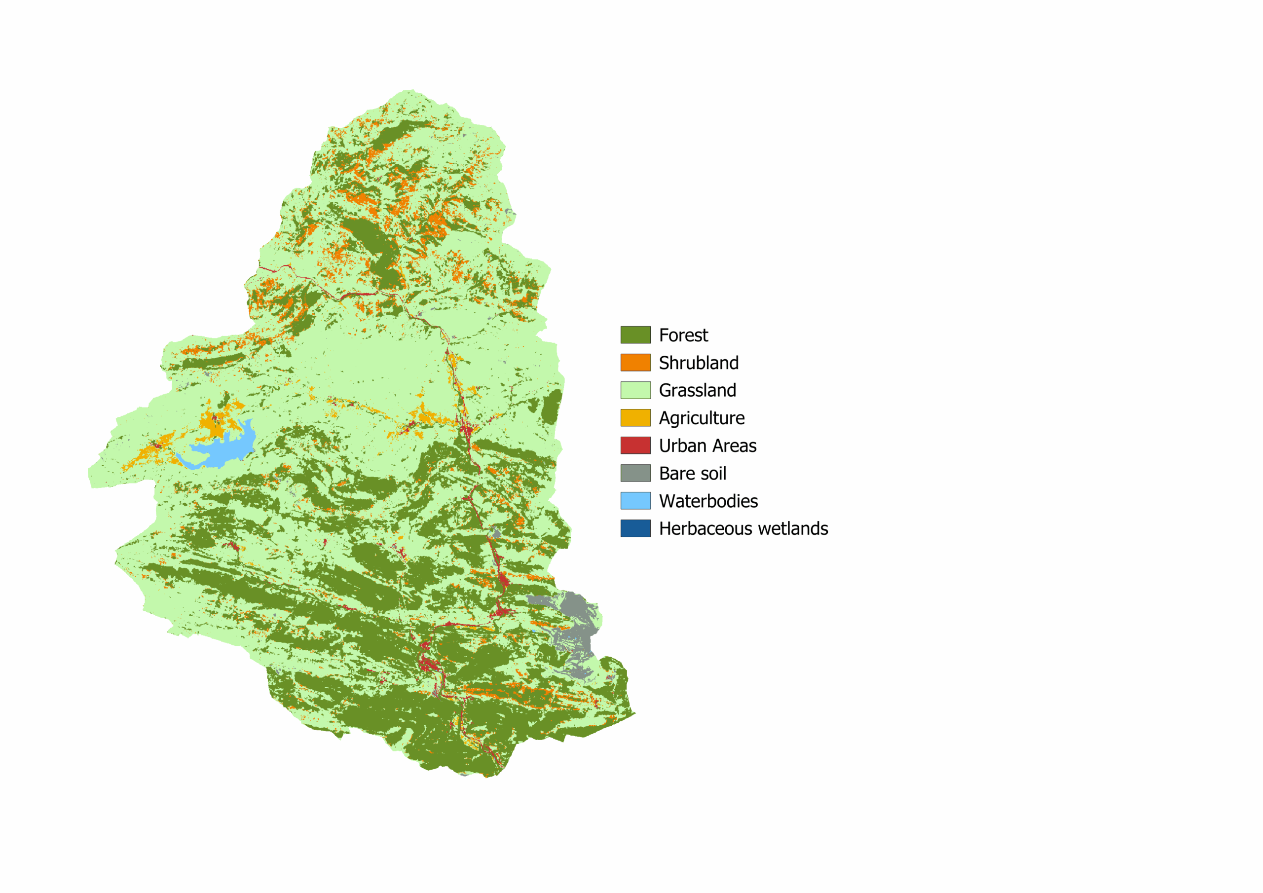
After completing the characterization stage for the WEFE tool, we leveraged the European Space Agency (ESA) 2021 World Cover Map to develop a baseline LULC map for each BR.
The ESA LULC map is a freely accessible global land cover product at 10m resolution, offering eight land use categories: Forest, Shrubland, Grasslands, Agriculture, Urban Areas, Bare Soil, Waterbodies, and Herbaceous Wetlands.
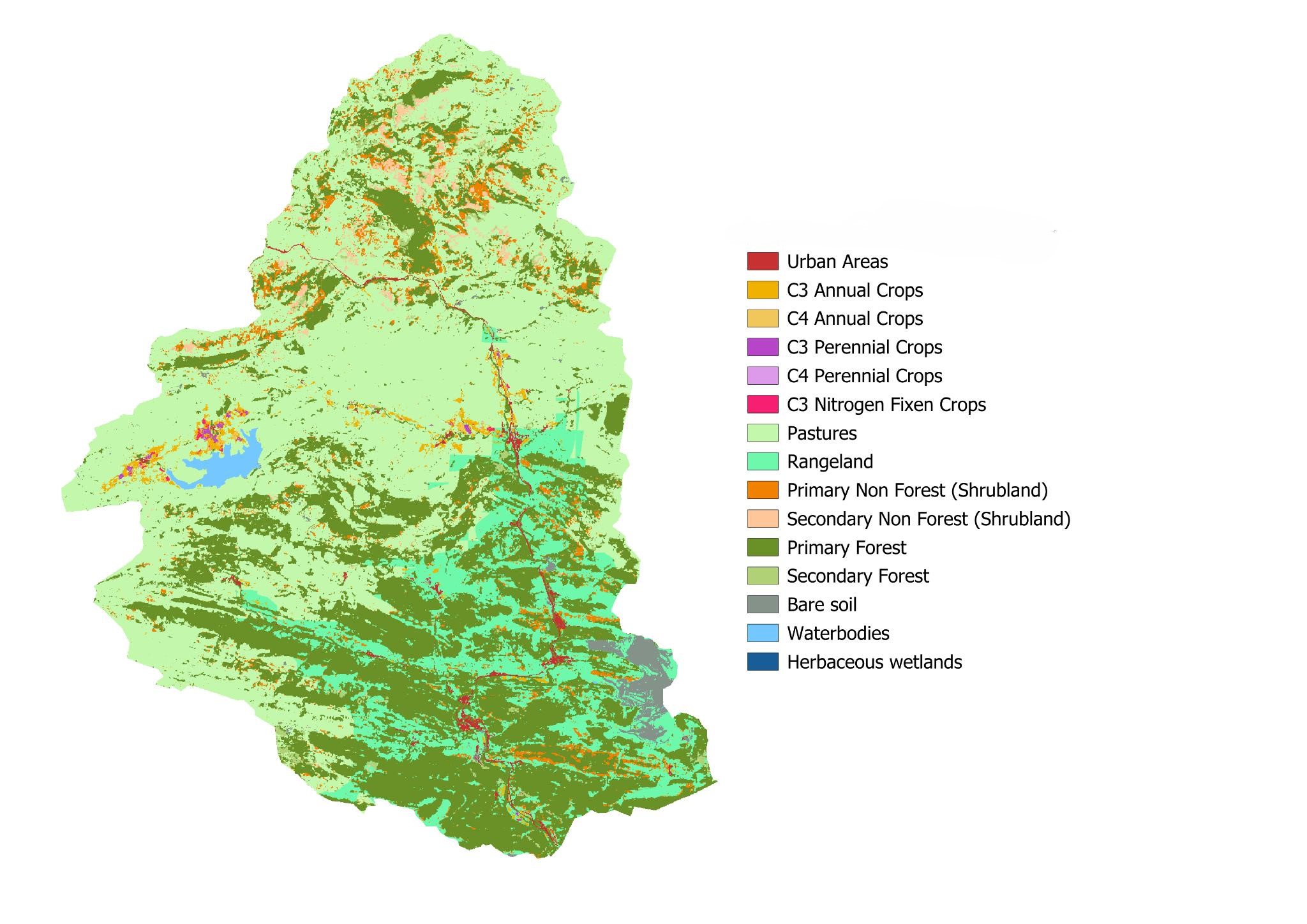
While the ESA LULC map offers an overall accuracy of 76.7% (Zanaga, D., et al., 2021), our WEFE approach requires a greater level of detailed categories to model alternative landscapes under different climate conditions and to estimate ecosystem services. Therefore, we enhanced the baseline by applying diverse global datasets to the ESA LULC map, including data from Global Forest Change, the World Aridity Index, and the Land Use Harmonization 2 Project (Hurtt, G. C et al., 2020).
The addition of this data distinguishes between primary and non-primary forests and shrublands, pastures, rangelands, and crop types, while maintaining existing categories including water bodies, bare/sparse vegetation, and herbaceous wetlands. The result is a more distinguished land use and cover map, serving as the baseline for each biosphere reserve.
Step 3: The Simulation of Climate Scenarios: A Combination of RCPs and SSPs
These baselines seek to replicate the LULC categories from the Land Use Harmonization 2 Project (Hurtt, G. et al., 2020), to project climate conditions using the four Representative Climate Pathways (RCP) defined at 2.6, 4.5, and 8.5 as described in van Vuuren, D.P. et al., (2011) combined with the Shared Socio-Economic Pathways (SSP) developed by Kriegler, E., et al (2012) to simulate landscape change under these combined scenarios. A detailed methodological process will be detailed in WP2 Deliverable D2.3.
Step 4: Applying InVEST Software to Model the Estimation of Ecosystem Services (ES)
InVEST Software was chosen as the methodology for estimating ES under the WEFE-SEM Tool for three main reasons:
First, the number of ES that can be modeled in InVEST allows the WEFE-SEM Tool to build more precise future projections of the landscape with a wider range of ES, allowing for deeper visualization of the change in structure and function of ES and its impact on a landscape. The more ES the tool can model, the stronger the land use and cover trade-offs made among stakeholders are, supporting improved decision-making for resilient landscape objectives.
Second, the software’s spatial resolution enables the use of available databases at global, regional, and local scales. This is advantageous for the WEFE-SEM Tool because not all BRs have equally strong datasets, and leveraging global data sources promotes cohesion across study areas, facilitating meaningful comparison and evaluation of landscape scenarios.
Third, at the same time, this flexibility allows for the customization of landscapes, as more tailored data from regional or local scales can be applied to the model.
Currently, the WEFE-SEM Tool is at this stage of development. Data is being prepared for input into InVEST software. The output will be a series of maps for each BR that demonstrates the change of various ES simulated by the combined Representative Concentration Pathways (RCPs) and Shared Socioeconomic Pathways (SSPs). The full process and methodological steps will be detailed in WP2 Deliverable D2.4.
Step 5: Optimization
At this stage of the WEFE-SEM Tool, we have a series of maps that depict the state of change in the land cover at the unit of the polygon for the baseline LULC map for each BR. The states in which the landscape unit (i.e., polygon) can be found are established, which consist of each land cover category from the baseline ESA 2021 LULC map modelled, producing alternatives of change for each polygon of the BR. An alternative is defined by the combination of current state and potential future state. Based on the list of alternatives, a preliminary decision space is constructed that specifies all possible alternatives for each polygon (Aquilúe et al., 2025).
During the optimization phase, we account for each site’s vocation (the land use for which it is best suited) to identify the bundles of ES delivered when specific objectives are maximized or minimized through targeted management strategies. This step translates the development visions and ES priorities set by BR managers into viable alternative landscape states. By filtering options through vocations, we narrow the universe of possibilities to a refined set of feasible states for each BR. For every state, the selected ES are quantified and compiled into a matrix (decision space) that feeds the optimization routine. The outcome is a portfolio of resilient landscape configurations. Because each configuration differs in both its vocation prioritizations and its objective settings, it delivers a distinct bundle of ecosystem services.
Tool for Decision support for a resilient landscape
The result is an optimized proposal of the BR landscape. At the final stage of optimization, the tool is refined, and an additional round of itinerary process is done with stakeholders to validate the results of the WEFE-SEM approach and the resulting resilient landscape. The refined proposal for the final resilient landscape seeks to support decision makers in landscape management decisions that align with WEFE resilience and choose landscape alternatives that support both the environmental and human well-being.
Work Cited
Aquilúe, N., Zaldo-Aubanell, Q., Salgado, J. Capizzi, G., Camps, J., Moreno, J., Pukkala, T., Trasobares, A. FORMES: A projection system for multi-objective forestry planning. 9th Congreso Forestal Español. June 2025.
Baratella, V., Pirelli, T., Giordano, R., Pagano, A., Portoghese, I., Bea, M., López-Moya, E., Di Fonzo, A., Fabiani, S., Vanino, S., Stakeholders analysis and engagement to address Water-Ecosystem-Food Nexus challenges in Mediterranean environments: a case study in Italy, Italian Journal of Agronomy, Volume 18, Issue 4, 2023,2200, ISSN 1125-4718, https://doi.org/10.4081/ija.2023.2200.
Hurtt, G. C., L. Chini, R. Sahajpal, S. Frolking, B. L. Bodirsky, K. Calvin, J. C. Doelman, J. Fisk, S. Fujimori, K. K. Goldewijk, T. Hasegawa, P. Havlik, A. Heinimann, F. Humpenöder, J. Jungclaus, Jed Kaplan, J. Kennedy, T. Kristzin, D. Lawrence, P. Lawrence, L. Ma, O. Mertz, J. Pongratz, A. Popp, B. Poulter, K. Riahi, E. Shevliakova, E. Stehfest, P. Thornton, F. N. Tubiello, D. P. van Vuuren, X. Zhang (2020). Harmonization of Global Land-Use Change and Management for the Period 850-2100 (LUH2) for CMIP6. Geoscientific Model Development Discussions. https://doi.org/10.5194/gmd2019-360
Kriegler, E., O’Neill, B.C., Hallegatte, S., Kram, T., Lempert, R.J., Moss, R.H., Wilbanks, T., The need for and use of socio-economic scenarios for climate change analysis: A new approach based on shared socio-economic pathways, Global Environmental Change, Volume 22, Issue 4, 2012, Pages 807-822, ISSN 0959-3780, https://doi.org/10.1016/j.gloenvcha.2012.05.005
Map of Global Aridity. Food and Agriculture Organization. United Nations Environmental Programme (UNEP).Map of aridity (Global – ~19km) – Datasets – “FAO catalog”
C. Hansen et al. High-Resolution Global Maps of 21st-Century Forest Cover Change.Science342,850-853(2013).DOI:10.1126/science.1244693
Monfreda, C., N. Ramankutty, and J. A. Foley (2008), Farming the planet: 2. Geographic distribution of crop areas, yields, physiological types, and net primary production in the year 2000, Global Biogeochem. Cycles, 22, GB1022, doi:10.1029/2007GB002947.
Natural Capital Project, 2025. InVEST 3.16.1. Stanford University, University of Minnesota, Chinese Academy of Sciences, The Nature Conservancy, World Wildlife Fund, Stockholm Resilience Centre and the Royal Swedish Academy of Sciences. https://doi.org/10.60793/natcap-invest-3.16.1
van Vuuren, D.P., Edmonds, J., Kainuma, M. et al. The representative concentration pathways: an overview. Climatic Change 109, 5 (2011). https://doi.org/10.1007/s10584-011-0148-z
Zanaga, D., Van De Kerchove, R., Daems, D., De Keersmaecker, W., Brockmann, C., Kirches, G., Wevers, J., Cartus, O., Santoro, M., Fritz, S., Lesiv, M., Herold, M., Tsendbazar, N.E., Xu, P., Ramoino, F., Arino, O., 2022. ESA WorldCover 10 m 2021 v200.
https://doi.org/10.5281/zenodo.7254221